
SECURED Landscapes
- Scientist: Peter Minang / Valentina Robiglio
- May 16, 2018, 12:42 a.m.
- Donor : Norwegian Agency for Development Cooperation (NORAD)
- Grant Ref : SECURED Landscapes: Sustaining Ecosystem and Carbon Benefits by Unlocking Reversal of Emissions Drivers in Landscapes
- Members : Martin Reyes (ICRAF), Marta Suber (ICRAF)
The project has been implemented by ICRAF in association with Partnership for the Tropical Margins (ASB) during 2013-2015. The project builds on the results of the REALU Project (Reducing Emission from All Land Uses) Phase I and Phase II (2009-2013), focusing on: (a) piloting incentives in five demonstrations landscapes in five countries (Cameroon, Congo, Indonesia, Vietnam and Peru); (b) exploring landscape investment and private sector engagement options; (c) developing frameworks for strategic and tactical nesting of landscapes to national level REDD+ and other relevant activities; and (d) development of globally relevant methods, policy and investment guidance for decision-making and negotiations in sustainable landscapes.
The project has been implemented by ICRAF in association with Partnership for the Tropical Margins (ASB) during 2013-2015. The project builds on the results of the REALU Project (Reducing Emission from All Land Uses) Phase I and Phase II (2009-2013), focusing on: (a) piloting incentives in five demonstrations landscapes in five countries (Cameroon, Congo, Indonesia, Vietnam and Peru); (b) exploring landscape investment and private sector engagement options; (c) developing frameworks for strategic and tactical nesting of landscapes to national level REDD+ and other relevant activities; and (d) development of globally relevant methods, policy and investment guidance for decision-making and negotiations in sustainable landscapes.
Project layers, maps and documents
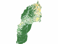
Land cover & land use in Irazola district in 2007
- April 6, 2018, 10:20 a.m.
Shapefile that corresponds to land cover & land use classes in Irazola district in 2007 based on Landsat imagery at a 30m spatial resolution. Data is part of SECURED Landsapes Project.
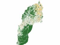
Land cover & land use in Irazola district in 2011
- April 6, 2018, 10:31 a.m.
Shapefile that corresponds to land cover & land use classes in Irazola district in 2011 based on Landsat imagery at a 30m spatial resolution. Data is part of SECURED Landscapes Project.
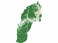
Land cover & land use in Irazola district in 2015
- April 6, 2018, 7:51 p.m.
Shapefile that corresponds to land cover & land use classes in Irazola district in 2002 based on Landsat imagery at a 30m spatial resolution. Data is part of SECURED Landscapes Project.
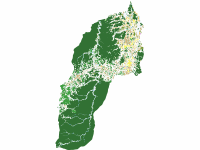
Land use & land cover in Irazola district in 2002
- April 6, 2018, 9:40 a.m.
Shapefile that corresponds to land cover & land use classes in Irazola district in 2002 based on Landsat imagery at a 30m spatial resolution. Data is part of SECURED Landscapes Project.
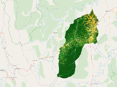
Land cover & land use in Irazola district (2002-2015)
- May 11, 2018, 7:42 a.m.
Land cover & land use in Irazola district (2002-2015)
Recent Posts
We work towards the application of GeoScience in real decision contexts, such as climate change adaptation, hydrological effects of changes in climate and land cover, targeting of agroforestry interventions, provision of soil fertility and surveillance advisory services for smallholder farmers, digital soil and land use/cover mapping, and measuring impacts of interventions, all using open source software.