Category archives: Software

Regreening Africa App and Data Reporting System (DRS) Trainings

Last update on Aug. 13, 2020.

Regreening Africa App and Data Reporting System (DRS) Trainings

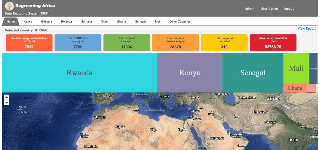
Geo Science Team has conducted Regreening Africa App and Data Reporting System (DRS) Trainings from time to time based on country teams request. Following are some of the links to training workshop videos. 


Data Reporting System (DRS) training For Regreening Africa Project. This training workshop video is useful for project admins and country Monitoring and ...

Continue reading

Introduction to data visualization with ggplot2

Last update on Jan. 20, 2020.


Presenter: Jason Kinyua


Presentation Materials:


ICRAFUseR: Introduction_Reading_data_into_R

Last update on Nov. 21, 2019.


Presenter: Aida Bargues Tobella


Presentation Recording:


Presentation Materials:


Download script here


Download the Data folder

ICRAFUseR: Introduction to R

Last update on Oct. 25, 2019.

Presenter: Faith Musili

Topics Covered:

  • What is R Programming language?
  • Why Learn R?
  • Who uses R?
  • R communities and groups
  • What is Rstudio?
  • Where to start
  • R packages
  • Data types in R
  • Good Practices when programming in R
  • Basic R

Presentation Materials:


New version of Africa Tree Finder on the Google Play Store

Last update on Nov. 7, 2017.

New version of Africa Tree Finder on the Google Play Store

A new version of the Africa Tree Finder is on the Google Play store with lots of improvements and new functionality. Have a look here: https://play.google.com/store/apps/details?id=com.icraf.gsl.africatreefinder&hl=en

ICRAF GeoScience Lab launches new Android App - Africa Tree Finder

Last update on Nov. 23, 2015.

ICRAF GeoScience Lab launches new Android App - Africa Tree Finder

ICRAF Geoscience Lab in partnership with IUCN with funding by DFID have developed a semi offline android [app](https://play.google.com/store/apps/details?id=org.icraf.gsl.iucn.treespecieslocator "Africa Tree Finder"), that can be used by extension officers, foresters, ecologist and farmers to help identify suitable tree species for their surrounding. The ...

Continue reading

R seminar series: Seminar 8

Last update on March 27, 2015.

We have conducted 8 R Brown-bag seminars till now. This week we decided to revisit some of the examples shown in previous seminars, participants were asked to write code in RStudio and show results (code writing practice session).  

See the presentation of seminar 8 below  


Data used in this seminar is available here and source ...

Continue reading

Aerial images from Kenya georeferenced by the ICRAF GeoScience Lab

Last update on Feb. 11, 2015.

Aerial images from Kenya georeferenced by the ICRAF GeoScience Lab

During the "Kenya Landuse Change" project conducted by the Climate Change Unit at ICRAF, several thousand aerial images were collected from surveys done in 1983 and 2012, respectively. During the last three months, the ICRAF GeoScience Lab has georeferenced this image archive to an accuracy of ~5m or better, with the help of six interns ...

Continue reading

Want to know what we are up to?

Last update on April 2, 2014.

In the GeoScience Lab we are constantly pushing the envelope on what we do with models and maps. This presentation gives you an idea of what we are up to at the moment:


About the Landscape Portal

Last update on March 5, 2014.

  • Page 1 of 2
  • 1
  • 2