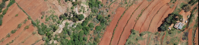
During the "Kenya Landuse Change" project conducted by the Climate Change Unit at ICRAF, several thousand aerial images were collected from surveys done in 1983 and 2012, respectively. During the last three months, the ICRAF GeoScience Lab has georeferenced this image archive to an accuracy of ~5m or better, with the help of six interns ...
You are using an outdated browser that is not supported by GeoNode.
Please use a modern browser like Mozilla Firefox, Google Chrome or Safari.
Tag archives: images
Aerial images from Kenya georeferenced by the ICRAF GeoScience Lab
Written by muhammad, Tor-G. Vagen on Feb. 11, 2015 in GIS, Software.
Last update on Feb. 11, 2015.
Short url : http://landscapeportal.org/blog/21/
Discussions : No comments yet. Be first to comment!
Welcome
The Landscapes Portal blog is where you can share ideas and experiences on landscape level applications of GeoScience, as well as modeling and mapping in general.
Please do not hesitate to send us suggestions and/or requests for functionality also.
Recent Entries
- Farmer-managed natural regeneration as a land restoration strategy. Under what conditions does it work?
- Regreening Africa App and Data Reporting System (DRS) Trainings
- Data visualization with ggplot2 for intermediate and advanced users
- Introduction to data visualization with ggplot2
- Data manipulation in R
Categories
- Biodiversity 10 entries
- Deforestation 6 entries
- GIS 5 entries
- Land Degradation 10 entries
- New maps 4 entries
- R 23 entries
- Software 11 entries
- Soil Mapping 7 entries
- Training 16 entries
- Workshop 7 entries
Authors
- Tor-G. Vagen 26 entries
- s.palmas 1 entry
- tor2 1 entry
- eopiyo 5 entries
- PMakui 1 entry
- faith 5 entries
- Leigh Winowiecki 1 entry
- admin 15 entries
- aida.bargues.tobella 2 entries
- madelonlohbeck 3 entries
- JWanjara 2 entries
- jaysnm 1 entry
- muhammad 4 entries
Tags
- Aerial
- Africa
- agroforestry
- Android
- capacity building
- data analysis
- Data Manipulation
- deforestation
- DRS
- Examples
- FLR
- gdal
- ggplot
- ggplot2
- gis
- ICRAF_useR
- images
- land
- landscapeportal
- Landscapes
- LDSF
- Machine Learning
- monitoring
- Portal
- Project
- R
- Regreening
- Reproducibility
- resoration
- restoration
- R programming
- seminars
- sentinel landscapes
- software
- soil infiltration capacity
- statistics
- training
- water
- workshop
Recent Comments
- No comments yet.
Random Entries
Popular Entries
- No entries yet.
2024 © World Agroforestry Centre | Powered by GeoNode version 2.4.1 | Help | About