The landscapeportal, World Agroforestry Centre (ICRAF) website dedicated to sharing, visualization and in the future processing of spatial information, uniquely generated by ICRAF, was officially added to the Geonode gallery as a show case of organizations that uses Geonode, and open source Django web framework, that is used to create sites for sharing and distributing ...
Archives 2014
Landscapeportal added to the Geonode gallery and mentioned at FOSS4G2014
Written by on Nov. 5, 2014 .
Last update on Nov. 5, 2014.
Landscape portal at annual CGIAR-CSI meeting, Enschede
Written by on Oct. 14, 2014 in Workshop.
Last update on Oct. 28, 2014.
The ICRAF GeoScience Lab (GSL) recently participated in the CGIAR CSI meeting in Enschede, the Netherlands. During
this meeting, the Landscapes Portal was presented (presentation link)
along with some of its salient features (e.g time series tools, blog module etc.).
CGIAR is in the process of finalizing its Open Data policy and soon all ...
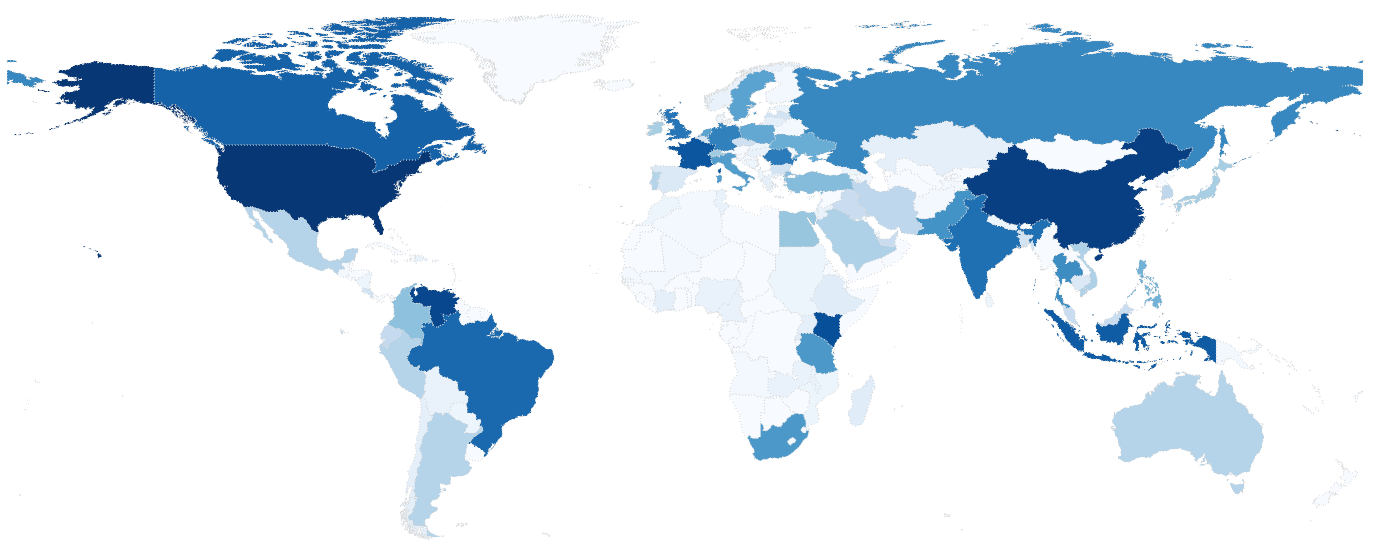
After six months (of inauguration, version 3), our data portal is growing day by day. About two months back we created an extent map of all the data sets in our portal (see below).
This time we decided to create a video. It shows the extent of all the data sets in landscape portal.
Cool ...
Explore data from our network of LDSF sites in the Sentinel Landscapes
Written by on Aug. 5, 2014 in Biodiversity, Land Degradation, Deforestation, Soil Mapping.
Last update on Aug. 5, 2014.
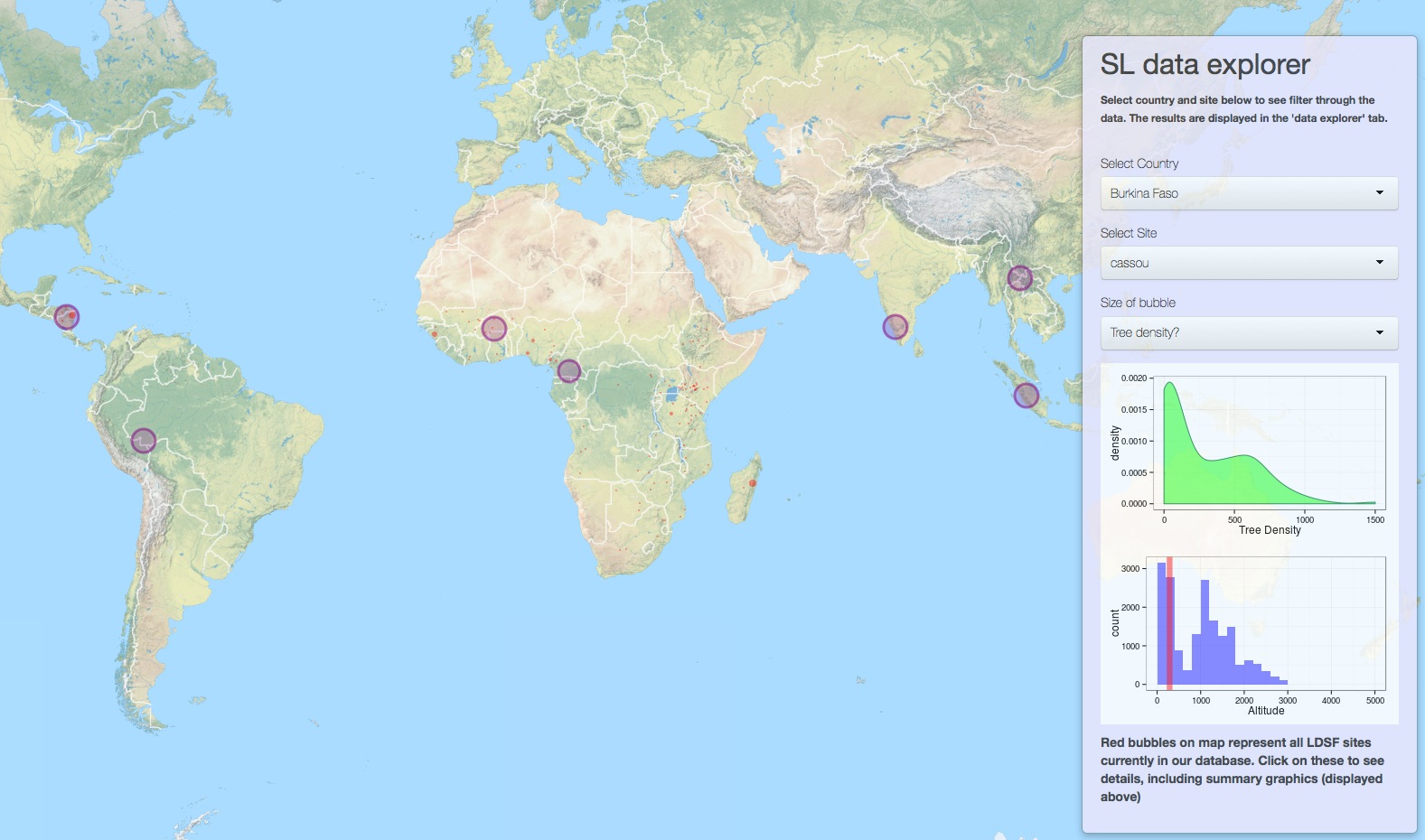
We are in the process of developing an interactive online mapping and analytical platform, and have just released a test version for the Sentinel Landscapes initiative. Click here to run the application in a new window in your browser. You can also view the sites on the Landscapes Portal here.
Usage statistics for the Landscapes Portal
Written by on June 4, 2014 in GIS, New maps.
Last update on June 26, 2014.
The Landscapes Portal is growing rapidly. Into our fourth month, the Landscapes Portal has around five hundred unique data sets with complete meta-data and more than two hundred registered users that are uploading and sharing spatial data and maps. We saw a lot of interest in the last two months with more than four thousand ...
Mapping the source of soil erosion
Written by , on May 21, 2014 in Land Degradation.
Last update on May 21, 2014.
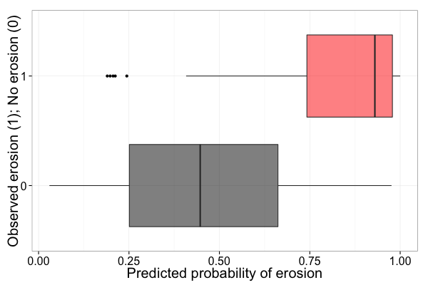
Predicting soil erosion
Conventional soil erosion models are generally based on the Universal Soil Loss Equation (USLE), or a revised (RUSLE) or modified (Williams and Berndt (1977)) version of the USLE. Betrie et al (2011) used the Soil and Water Assessment Tool (SWAT), which uses MUSLE to compute soil erosion, to model sediment transport in ...
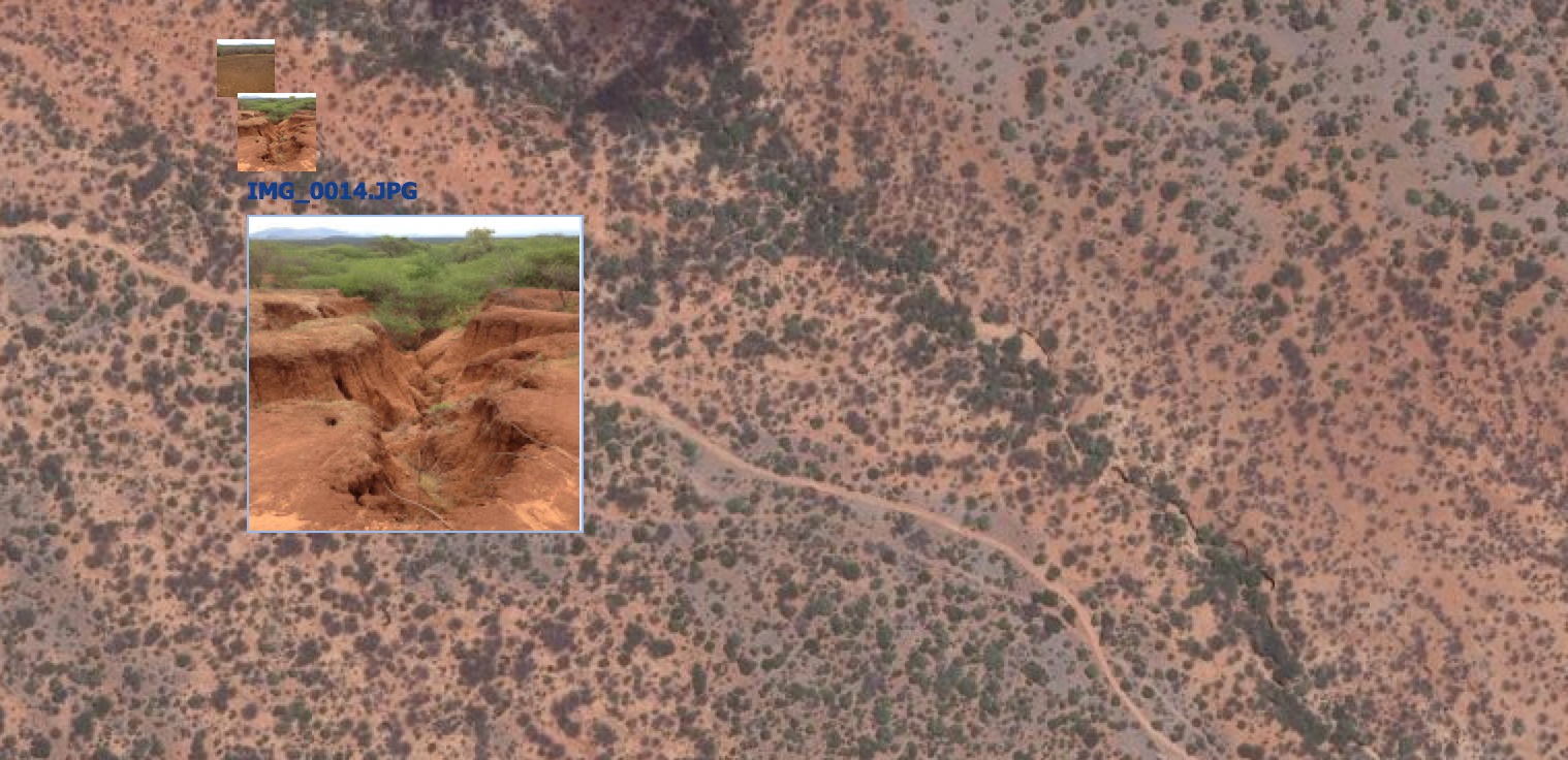
Adding geotagged photos to your map can be a powerful way to visualize the landscape that you are mapping, or even as a way to validate your mapping outputs. In the Landscapes Portal you can do this in three simple steps when creating a new map or when editing one of the existing maps on ...
Want to know what we are up to?
Written by on April 2, 2014 in Software, New maps.
Last update on April 2, 2014.
In the GeoScience Lab we are constantly pushing the envelope on what we do with models and maps. This presentation gives you an idea of what we are up to at the moment:
Mapping soil functional properties using multilevel models
Written by on March 13, 2014 in R, Soil Mapping.
Last update on March 13, 2014.
>*Tor-Gunnar Vågen (ICRAF), Leigh Winowiecki (CIAT), Lulseged T. Desta (CIAT) and Jerome E. Tondoh (CIAT)*
In this document we present examples of R functions and scripts that may be used to generate local maps of soil functional properties based on for example remote sensing data, climate surfaces and/or digital elevation models and their derivatives ...
Landscapeportal Workshop @ ICRAF
Written by on March 7, 2014 in Training, Workshop.
Last update on March 12, 2014.
The GeoScience Lab has the pleasure of inviting you to a one day workshop on how to use the Landscapes Portal to share, download, visualize and analyse spatial data, scheduled for 12 March 2014 from 10:00am EAT time at the Lundgren Auditorium, World Agroforestry Centre. This is a follow up to the seminar done ...
Monthly archives
- January 2014
- February 2014
- March 2014
- April 2014
- May 2014
- June 2014
- August 2014
- October 2014
- November 2014